NASA Empowers Energy Projects by Providing Global Earth Observation Data
NASA strives to understand the universe, whether that be the stars above us or Earth around us. One way NASA focuses on the Earth is through satellite, ground, and airborne Earth observations and modeling. NASA’s Earth Science projects work to further understand the Earth and its systems to better help humanity now and in the future. One such component is energy, which is a vital resource that impacts daily life for millions of people across the world. NASA’s Prediction of Worldwide Energy Resources (POWER) project support efforts toward energy resilience and efficiency by providing value-added global solar and meteorological data parameters. Since 1988, the data POWER provides has been leveraged for numerous projects concerning solar, wind, and hydroelectric energy. Since 2018, POWER has answered 764.5 million data requests to more than 1.4 million unique users. The project offers more than 1,000 different parameters that can help companies, researchers, and agencies make actionable decisions, accelerate learning, and improve outcomes in energy, buildings, and agroclimatology sectors. The breadth and no-cost accessibility of POWER’s analysis-ready data allows for a wide range of application areas to achieve organizational goals in energy independence and resilience. The project leverages NASA’s Clouds and the Earth’s Radiant Energy System (CERES) mission and the NASA Langley Research Center’s Surface Radiation Budget (SRB) in association with the Global Energy and Water Exchanges (GEWEX) program, which:
Provides solar data in hourly, daily, monthly, and yearly temporal and long-term averages.
Dates back to 1984.
Supports projects like solar panel sizing, power generation forecasting, and solar thermal systems for buildings.
POWER uses Modern-Era Retrospective analysis for Research and Applications, Version 2 (MERRA-2) data products, which:
Provides meteorological parameters such as temperature, wind, and humidity in hourly, daily, monthly, and yearly temporal and long-term averages.
Dates back to 1981.
Supports efforts such as wind turbine analysis, hydropower studies, and building energy efficiency.
[caption id="attachment_236477" align="aligncenter" width="740"]
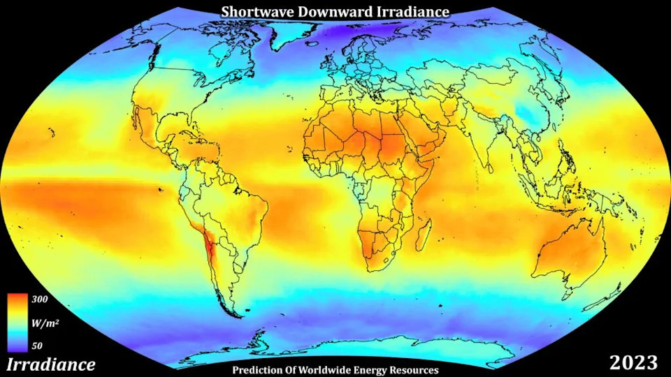
Global visualization of surface shortwave downward irradiance annually for 2023 expressed in watts per meter squared. Source: Christopher Higham, NASA POWER[/caption]
POWER’s Data Services and Capabilities
The POWER project prides itself on providing accessible pathways to leveraging Earth observation data for its users. Tools such as the Data Access Viewer (DAV) and PaRameter Uncertainty ViEwer (PRUVE) allow users to easily access and compare data. Along with these tools, POWER also offers geospatial services, allowing users to not only visualize POWER data, but also work efficiently with geographic information systems (GIS) applications. In addition, NASA’s partnership with Amazon Web Services allows free access to the full POWER data catalog. The POWER DAV is a web application tool that allows direct access to the project’s application programming interface (API) and visualization plots. Data from the DAV can be either downloaded or integrated into software and applications for easy and efficient data acquisition. Users can also subset the data by selecting the user community, location, time period, parameters, and file type so they are only acquiring the data they need. Users can also generate integrated reports to support heating and cooling system implementation to assist in building design. HUBER SE, a wastewater company in Germany, accesses POWER data through the DAV to plan and implement drying systems that maximize efficiency. HUBER SE specializes in treating sewage sludge through solar drying, a process sensitive to climate variability. The company uses the POWER DAV to acquire surface shortwave downward irradiance, temperature, and relative humidity to optimally adapt its systems for each site. “[POWER] enables us to develop tailor-made solutions that maximize the efficiency of the systems and at the same time ensure their long-term profitability. This gives us a divisive and competitive advantage on the market,” said Moritz Marschall, a representative from HUBER SE. PRUVE, a new tool being developed by the POWER team, will serve as an online data validation application using statistical analysis and visualization to compare in situ surface site data. Data validation is important to ensure consistency and accuracy. The comparison data will be sourced from the GEWEX program and Global Climate Observing System (GCOS) Baseline Surface Radiation Network (BSRN) for solar data. The meteorological comparison data will be acquired from the National Oceanic and Atmospheric Administration (NOAA). One of POWER’s other service offerings is geospatial services, which provides the GIS community friendly formats to integrate data into developing their own tools. The DAV and PRUVE tools are examples of how users can leverage geospatial services in the back end of development. [caption id="attachment_236479" align="aligncenter" width="740"]
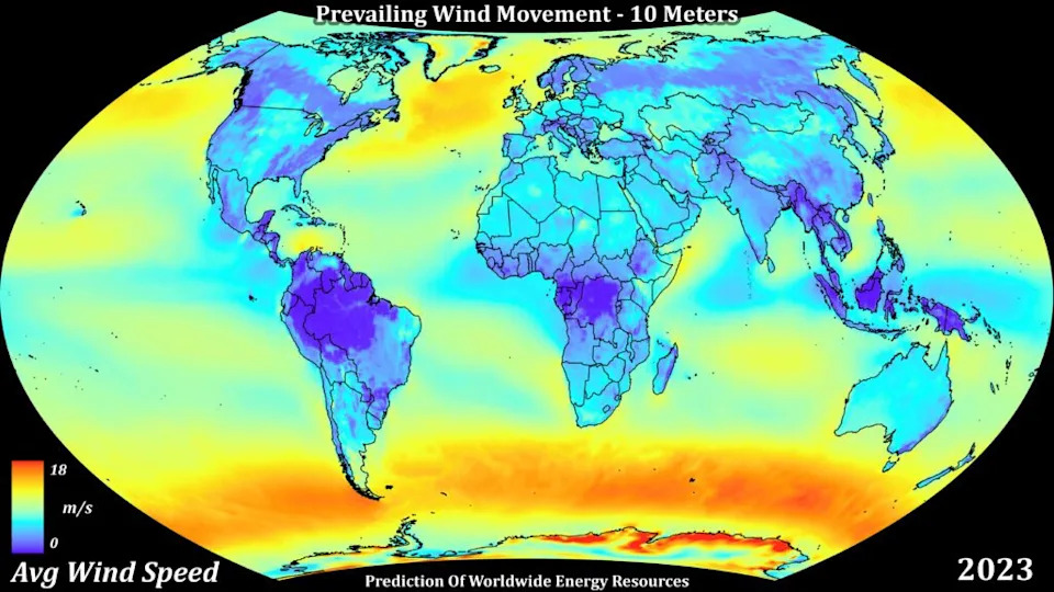
Global visualization using POWER’s image services showing average wind speed in 2023 at 10 meters above the surface, expressed in meters per second. Source: Christopher Higham, NASA POWER[/caption]
POWER Users and Their Impact
A large focus area of the NASA POWER project is user engagement to capture current and emerging requirements, use cases, and feedback. User driven feedback helps identify new parameters, tools, and areas of support. Through events like the project’s annual Global Community Summit, users can engage directly with POWER project leadership and developers to voice their opinions and needs for future improvements to help further their work. For example, users said they wanted better control of parameter searches with enhanced filter features on the POWER website, so the team created the Parameter Manager and Search Tool. Saildrone is a U.S.-based manufacturer of unmanned surface vehicles that are powered by wind and solar energy. The company uses POWER’s hourly solar data to estimate the amount of power that will be generated by the solar panels on the drones. The drones collect meteorological and oceanographic data as well as provide maritime domain awareness for the U.S. military. Saildrone has adjusted mission timelines and instrument payloads based on analyses that use POWER data, saving both time and money on objectives. Another company, Alpha 311, uses POWER’s wind speed and wind direction parameters to retrofit vertical axis wind turbines to new and existing infrastructure. To date, POWER data has been applied in Alpha 311 project proposals in 68 countries to help a range of organizations from schools and hospitals to commercial manufacturing plants and sports stadiums deploy renewable energy technology around the globe. POWER also supports other types of projects like Produced Water Ecoservices (PWES), based in Colombia. The ability to treat wastewater from oil and gas plants, also known as produced water, onsite saves on transport costs, shortens the water treatment cycle, and reduces risks of environmental spillage. PWES treats produced water from industrial facilities through mechanical evaporation. The process is sensitive to climatological factors, so PWES uses the POWER DAV to acquire meteorological data to return produced water to a clean state. To date, PWES has treated over one million barrels of produced water with the help of POWER data. Recently, the POWER project released new hydrological parameters from NASA’sIntegrated Multi-satellitE Retrievals for GPM (IMERG) that can be used in research and commercial applications. NASA’s IMERG precipitation data provides a higher resolution than the previous MERRA-2 version. Precipitation data has been used in studies to understand the correlation between meteorological factors and water inflow to hydropower plants. The researchers used POWER data in forecasting models to conclude that temperature and precipitation were the greatest factors affecting inflow. Another group studied the inflow for a hydroelectric power plant reservoir using NASA POWER meteorological parameters to establish the precedent at which data parameters should be used in future machine learning models concerning water inflow. NASA POWER hopes to reach new users and support more energy-focused missions. If you would like to learn more about the data tools and services the project offers, please email the POWER project at [email protected]. Be on the lookout for information about the virtual 2025 Global Community Summit, which will be held this fall and check out the POWER website for updates and a date to be released soon. —Zoe Waring is a scientific and technical writer for the NASA POWER project team. Paul Stackhouse Jr., PhD is a senior research scientist at the NASA Langley Research Center in Hampton, Virginia and leads the POWER team. He also leads the NASA Langley Research Center SRB project, and is a science team member of the CERES project and co-leads the FLASHFlux (Fast Longwave and Shortwave radiative Fluxes) working group. Both projects produce radiative fluxes using satellite analysis, and the latter produces low latency estimates of top-of-atmosphere and surface radiation data products from CERES. Both data sets are key inputs to the POWER web suite. Falguni Patadia, PhD is a research physical scientist at the NASA Langley Research Center in Hampton, Virginia and serves as the deputy lead for the POWER project.